


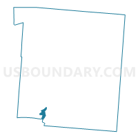
0040 DEF-T-LP Voting District, Warren County, Ohio
About
Outline

Summary
| Unique Area Identifier | 652993 |
| Name | 0040 DEF-T-LP Voting District |
| County | Warren County |
| State | Ohio |
| Area (square miles) | 1.21 |
| Land Area (square miles) | 1.08 |
| Water Area (square miles) | 0.13 |
| % of Land Area | 89.06 |
| % of Water Area | 10.94 |
| Latitude of the Internal Point | 39.30407270 |
| Longtitude of the Internal Point | -84.26141260 |
Maps

Graphs
Select a template below for downloading or customizing gragh for 0040 DEF-T-LP Voting District, Warren County, Ohio


Neighbors
Neighoring Voting District (by Name) Neighboring Voting District on the Map
- 0039 DEF-T-KM Voting District, Warren County, OH
- 0061 HAM-T-S Voting District, Warren County, OH
- 0084 DEF-T-SEB Voting District, Warren County, OH
- 0086 DEF-T-SEC Voting District, Warren County, OH
- 0103 HAM-T-WA Voting District, Warren County, OH
- 0115 DEF-T-SMA Voting District, Warren County, OH
- 0122 HAM-TWP-WB Voting District, Warren County, OH
- 0141 DEF-T-S Voting District, Warren County, OH
- 0164 HAM-T-WM Voting District, Warren County, OH
- Voting District SYMMES C, Hamilton County, OH
- Voting District SYMMES O, Hamilton County, OH
Top 10 Neighboring County Subdivision (by Population) Neighboring County Subdivision on the Map
- Deerfield township, Warren County, OH (36,059)
- Hamilton township, Warren County, OH (23,556)
- Symmes township, Hamilton County, OH (14,683)
Top 10 Neighboring Place (by Population) Neighboring Place on the Map
Top 10 Neighboring Unified School District (by Population) Neighboring Unified School District on the Map
- Little Miami Local School District, OH (29,636)
- Loveland City School District, OH (26,276)
- Kings Local School District, OH (24,764)
Top 10 Neighboring State Legislative District Lower Chamber (by Population) Neighboring State Legislative District Lower Chamber on the Map
Top 10 Neighboring State Legislative District Upper Chamber (by Population) Neighboring State Legislative District Upper Chamber on the Map
Top 10 Neighboring 111th Congressional District (by Population) Neighboring 111th Congressional District on the Map
Top 10 Neighboring Census Tract (by Population) Neighboring Census Tract on the Map
- Census Tract 322.01, Warren County, OH (18,574)
- Census Tract 320.03, Warren County, OH (7,112)
- Census Tract 243.03, Hamilton County, OH (7,024)
- Census Tract 320.07, Warren County, OH (6,467)
- Census Tract 322.02, Warren County, OH (5,774)